PrésentationÀ proximitéÉvaluationsGagnez des prixDétailsRecommandés
Partager à
Harlech Road and Lugard Road Circular Walk, The Peak
山頂夏力道和盧吉道環迴步行徑2,9
110 évaluations
 selon 4 évaluations
Ouvert toute l'année, 24 heures sur 24, 7 jours sur 7
Temps de visite recommandé :1-3 heures
Adresse:
34 Lugard Rd, The Peak, Hong KongCarte
Ce qu'en disent les voyageurs :
Visitez le jour pour marcher et rester jusqu'au soir et le soir sur le pont de l'observatoire pour une vue spectaculaire des lumières de la ville.
Plus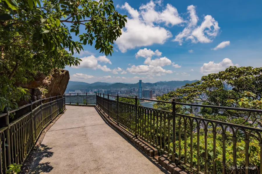
Voir les(1)
Aimé par 23
À proximité de Harlech Road and Lugard Road Circular Walk, The Peak
Évaluations de Harlech Road and Lugard Road Circular Walk, The Peak
Certaines évaluations peuvent avoir été traduites par Google Translate (110 évaluations)Trip.com
 (4 évaluations)TripAdvisor
Informations complémentaires
Vous pourriez également aimer

Hong Kong Disneyland
10
4,7/549716 évaluations
Save 5,85 €
À partir de 70,41 €

Ocean Park Hong Kong
9,1
4,7/531451 évaluations
Save 16,70 €
À partir de 42,73 €
Hong Kong Observation Wheel
7,9
4,6/51223 évaluations
À partir de 2,39 €

Water World Ocean Park Hong Kong
6,7
4,6/5716 évaluations
Save 2,98 €
À partir de 30,44 €
Découvertes à proximité
Hong Kong Disneyland | Ocean Park Hong Kong | Victoria Peak | Tsim Sha Tsui | Hong Kong Palace Museum | Ngong Ping 360 | Île de Lantau | Victoria Harbour | Hong Kong Space Museum | The Peak Tram | Central | Hong Kong Observation Wheel | Lan Kwai Fong | Temple de Wong Tai Sin | Baie de Repulse | Sky100 Observation Deck | Île de Lamma | Madame Tussauds | M+ | Star Ferry | Avenue des Stars | LEGOLAND Discovery Centre Hong Kong | AsiaWorld-Expo | 2024 IU H.E.R. WORLD TOUR CONCERT IN HONG KONG | Water World Ocean Park Hong Kong | Hong Kong Tramways | Hong Kong K11 MUSEA | Hong Kong Macau Ferry Terminal | The Peak Tower | West Kowloon Cultural District
Types de découvertes populaires à Hong Kong
Parcs | Parcs urbains | Parcs d'attractions | Aquariums | Architecture et monuments | Jardins | Quartiers en vedette | Architectures historiques | Sports de plein air | Randonnée | Sports nautiques | Randonnée/balade à vélo | Sites religieux | Églises et cathédrales | Temples | Temples commémoratifs | Nature | Attractions | Îles/péninsules | Montagnes | Sites historiques | Sites historiques | Cimetières | Salle de sport | Stades | Terrains de basket-ball | Terrains de football | Mode de vie | Bibliothèques | Centres de divertissement
Destinations prisées
Voyages à Vientiane | Voyages à Guadeloupe | Voyages à Bangalore | Voyages à Abou Dabi | Voyages à Sétif | Voyages à Saint-Sébastien | Voyages à Ottawa | Voyages à Algérie | Voyages à Bodrum | Voyages à Sfax | Voyages à Koh Tao | Voyages à Pise | Voyages à Dubaï | Voyages à Taipei | Voyages à Amman | Voyages à Mejjat | Voyages à Minorque | Voyages à Chooz | Voyages à Dombasle-en-Xaintois | Voyages à Ozamiz | Voyages à Crapeaumesnil | Voyages à Oakland | Voyages à Préhy | Voyages à Chambon-Sainte-Croix | Voyages à Zhuzhou | Voyages à Huai Rat | Voyages à Brimeux | Voyages à Saulchoy-sous-Poix
Attractions recommandées dans les destinations populaires
Paris, attraction à proximité | Lyon, attraction à proximité | Alger, attraction à proximité | Bangkok, attraction à proximité | Tunis, attraction à proximité | Marseille, attraction à proximité | Nice, attraction à proximité | Bali, attraction à proximité | Marrakech, attraction à proximité | Istanbul, attraction à proximité | Nantes, attraction à proximité | Casablanca, attraction à proximité | Montréal, attraction à proximité | Toulouse, attraction à proximité | Genève, attraction à proximité | Lisbonne, attraction à proximité | Bordeaux, attraction à proximité | Dubaï, attraction à proximité | Rome, attraction à proximité | Tokyo, attraction à proximité | Kuala Lumpur, attraction à proximité | Madrid, attraction à proximité | Séoul, attraction à proximité | Bruxelles, attraction à proximité | New York, attraction à proximité | Milan, attraction à proximité | Londres, attraction à proximité | Athènes, attraction à proximité | Porto, attraction à proximité | Oran, attraction à proximité
Nous contacter
À propos
Modes de paiement
Nos partenaires
Copyright © 2024 Trip.com Travel Singapore Pte. Ltd. Tous droits réservés
Gestionnaire du site : Trip.com Travel Singapore Pte. Ltd.
Gestionnaire du site : Trip.com Travel Singapore Pte. Ltd.
Visitez le jour pour marcher et rester jusqu'au soir et le soir sur le pont de l'observatoire pour une vue spectaculaire des lumières de la ville.
On sort de la porte de la baie de fer A3, en remplaçant 9 roues vers Shi Ou, on descend à la station de la baie terrestre jusqu'à huit trous de longs de la route la plus belle. Vous pouvez voir le paysage de montagne magnifique tout au long de la route. Les fleurs de la route sont aussi belles, l'air est très frais et l'humeur est très confortable.
Le sommet de la montagne de Taiping est une région touristique célèbre et une zone de réconciliation pour les riches. La route de montée autour de la montagne est un endroit où beaucoup de Hong Kong aiment venir. Les étapes sont détruites par les forêts, très calmes et l'air frais. La clé est souvent de se joindre à un riche ou à une star de film.
Il est toujours un endroit brillant pour profiter et capturer la vue de Hong Kong et le soir. Quand je marche autour de la zone de la vue de pointe, il n'est pas aussi crowded que je pensais, et c'est donc pour moi une chose précieuse d'avoir une heure de temps calme pour vivre juste en ce moment, de respirer la gratitude et de respirer le stress.
Le chemin de la montagne est situé à l'ouest du sommet de la montagne, à environ 3 kilomètres de longueur, et il faut environ une heure pour aller à pied. Le chemin est le chemin de la route de Pitching, sans grade, sans chasse, pas de problème avec les personnes âgées ou les enfants.
Everyone knows that you can watch the night scenery on the top of Taiping Mountain by cable car. In fact, there is a very good hiking route on the top of the mountain, called the Hong Kong Island Trail, which can go down the mountain from the top to the University of Hong Kong. We take a cable car up the hill, come down 428 from the skyscraper on the top of Taiping Mountain, start hiking on the right side, start on Luji Road, and then walk around the top of Taiping Mountain according to the sign of Hong Kong Island Trail. There are very few people on the road. It's the local people who run by chance. In fact, this is a good place for jogging. There are many trees, the air is very good, and there are many plant descriptions. Along the way, there was a fog lock in Xianqiao, one of Hong Kong's eight scenic spots. The best way to get down from Luji Road to Keyton Road is to go down Luji Road to the intersection of Xiali Road in the first half of the map. The problem is that we ordered Agam shrimp on the top of the mountain. If we didn't order this meal, we would definitely go down directly. After we went up the hill, we went down again from Xiali Road and Kerton Road, which was equivalent to walking a circle and a half. Along the way, there are many trees and flowers, as well as private villas, you can also see the scenery from different directions. The road signs along the way are very clear. Luji Road and Xiali Road are the two halves of the mountain. Luji Road is 2.25 kilometers and takes about 45 minutes. The peak of Xiali Road is 1.25 kilometers and about 30 minutes. The Pok Fu Lin Pond in the other direction is another walking route recommended by the website of the Hong Kong Tourism Development Bureau. It takes longer time. Along the way, you can go through the Longhu Mountain Country Park until you reach the gate of the University of Hong Kong.
L'air est bon, calme, bon marcher, revenir dans la cave. Si vous marchez lentement, plus d'une heure, c'est très approprié.