冰臼山莊
🍀 places to go during the dry water period 🌈 highlights: hail, is glacier erosion, formed by flowing water erosion, Guizhou's most typical representative, one in Guanling County, and the other in Pingtang County, is not only a unique scenery, but also has a high geographical research value. The valley of Guanling is deep, the valley bottom is about 600 meters away from the top of the mountain, and the climate is warm. Therefore, the valley has formed a warm local climate, with many temperate and tropical plants, such as bananas (the fruit is edible, like bananas, and not delicious), sugar cane, and many large elm trees. 🚗 Self-driving navigation: Guiyang departs for 3 hours and navigates to "Guanling Hail". Baidu map has been online at present. 📖 Itinerary route: Hiking mileage is about 6 kilometers, hiking in the river valley, you will climb boulders, waterfalls are only for viewing, do not climb. ‼️ pay more attention to the forward route, you can wear downstream from the upstream, or you can wear downstream, upstream dam-downstream substation. Environmental protection must be paid attention to, no one maintains, every time I go to the waterfall point is a disposable tableware, it is uncomfortable to look at, which is why our outdoor people sometimes don't want to share the express secret. #Small group free punch card recommendation #Outdoor base camp #Play outdoor
MoreRecommendations Near 冰臼山莊
冰臼山莊 Reviews: Insider Insights and Visitor Experiences
Some reviews may have been translated by Google TranslateYou Might Also Like
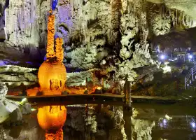
Zhijin Cave
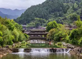
Xijiang Qianhu Miao Village
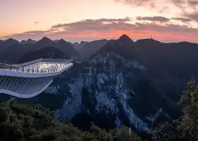
Dashiwei Tiankeng Group
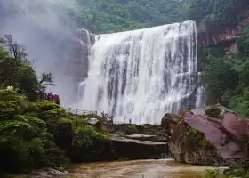
Chishui Danxia Tourist Area · Great Waterfall
Nearby Attractions
Popular Types of Attractions in Zhenning
Popular Restaurants in Zhenning
Popular Destinations
Recommended Attractions at Popular Destinations
Popular Ranked Lists
Popular Trip Moments
Popular Travel Types
More Things To Do in Zhenning
About
Site Operator: Trip.com Travel Singapore Pte. Ltd.
🍀 places to go during the dry water period 🌈 highlights: hail, is glacier erosion, formed by flowing water erosion, Guizhou's most typical representative, one in Guanling County, and the other in Pingtang County, is not only a unique scenery, but also has a high geographical research value. The valley of Guanling is deep, the valley bottom is about 600 meters away from the top of the mountain, and the climate is warm. Therefore, the valley has formed a warm local climate, with many temperate and tropical plants, such as bananas (the fruit is edible, like bananas, and not delicious), sugar cane, and many large elm trees. 🚗 Self-driving navigation: Guiyang departs for 3 hours and navigates to "Guanling Hail". Baidu map has been online at present. 📖 Itinerary route: Hiking mileage is about 6 kilometers, hiking in the river valley, you will climb boulders, waterfalls are only for viewing, do not climb. ‼️ pay more attention to the forward route, you can wear downstream from the upstream, or you can wear downstream, upstream dam-downstream substation. Environmental protection must be paid attention to, no one maintains, every time I go to the waterfall point is a disposable tableware, it is uncomfortable to look at, which is why our outdoor people sometimes don't want to share the express secret. #Small group free punch card recommendation #Outdoor base camp #Play outdoor